

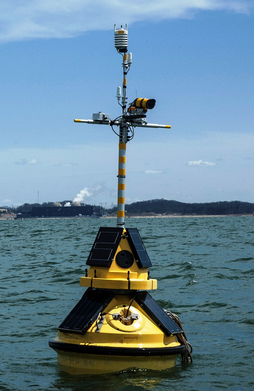
USA fleet member Cook Nuclear Plant has again launched its high-tech weather buoy in Lake Michigan. This year, in addition to making the extensive weather and water data available to the public online, there is also a camera providing still and video clips.
The buoy is equipped with a range of high-tech instruments that can transmit air temperature, wind speed and direction, water current speed and direction, wave height and water temperatures at several depths below the surface. The still images and video clips are taken once each hour and can also be accessed online to see the exact conditions out on the lake. Information about the buoy and a link to real-time data is available at http://bit.ly/cookbuoy and www.CookInfo.com.
The buoy was originally launched in 2011 by Cook to collect data for a two-year water intake study at the plant. The data was made available to the public and became so popular with recreational boaters and fishing enthusiasts that Cook has continued to launch the buoy each spring even though the water intake study is complete.
“We know that boaters love the data, and the addition of the images is a great safety feature,” said Cook Environmental Manager Jon Harner. “Conditions can change quickly on Lake Michigan and this new camera will provide up-to-date images boaters can use to stay safe.”
The buoy is deployed and maintained by LimnoTech, an Ann Arbor-based company specializing in Great Lakes monitoring and modeling. It is located two and one half miles from the shore in front of the plant in 70 feet of water. It will remain in operation through the fall.
LimnoTech is currently working directly with the Great Lakes Observing System (GLOS) and the National Oceanic and Atmospheric Administration (NOAA) to increase the number of environmental sensors in the Great Lakes and to improve the availability of the data to water quality managers and the public. The data from the buoy will be streamed every 10 minutes to GLOS, the National Data Buoy Center (NDBC) operated by NOAA, and Michigan Technological University’s Great Lake Research Center.
Data will be used directly by forecasters at the National Weather Service (NWS) offices in Northern Indiana and Grand Rapids, Mich. to improve predictions of hazardous weather including high waves and rip currents along the shoreline. Rip currents are particularly dangerous for local swimmers who are often unaware of the hidden threats these currents pose. Together, both offices are responsible for monitoring weather conditions along 240 miles of shoreline from Manistee, Mich. to Michigan City, Ind.
Data from the buoy will also feed Coast Guard information systems (via the NDBC) used to respond to distress calls from local boaters, enabling them to quickly assess wind and wave conditions before leaving port. Local boaters, fishermen, and swimmers can access the same information to make the decision whether to go out on the water or not.
